"LA CULTURE EN PARTAGE" avec F.MORIN
Archéologie et Architecture orientale
PALAIS OMEYYADE de QASTAL-Jordanie 685-705
Qastal fait partie des châteaux omeyyades édifiés sous la première dynastie
musulmane entre 685 et 750 ap. J.-C. .
en Palestine, Jordanie et Syrie autour de la capitale Damas.
Les 2 Qasr al-Hayr, al-Garbi et al-Sharki autour de Palmyre en Syrie,
Khirbat al-Mafjar près de Jéricho dans la vallée de la Mer Morte,
Qasr al-Hallabat, Qasr al-Kharana, Mishatta, le petit bain de Qusayr 'Amra,
en Jordanie sont les plus connus.
Ces châteaux fixaient des exploitations agricoles créatrices de revenus
nécessaires au fonctionnement de l'empire omeyyade et à son expansion.
« Bienheureux celui qui habite à Qastal, là où sont les maharib »
verset de Kuthayyir 'Azza,
poète panégériste du calife omeyyade Yazid II calife de 719 à 724,
fils de 'Abd al-Malik ibn Marwan calife de 685 à 705,
constructeur de la Coupole du Rocher à Jérusalem
et sans doute aussi celui de ce palais de Qastal.
En effet, Yazid II pouvait êre fier d'être le propriétaire du palais de son père 'Abd al-Malik
dont le règne fut le plus long de la dynastie omeyyade.
L'« Annual of the Department of Antiquities of Jordan » (A.D.A.J.) a publié en 1984 le compte-rendu des
premières fouilles archéologiques et de l'étude architecturale conduite par Frédéric Morin Architecte à partir de 1982,
incluant des décors architecturaux de pierres sculptées tout-à-fait remarquables :
1984 - Qastal - ADAJ = Annual of the Department of Antiquities of Jordan - 1984 - N°28 - pp.343-383
Les résultats de la deuxième mission de 1985, incluant la découverte de mosaïques exceptionnelles, ont été publiés
par l'« Annual of the Department of Antiquities of Jordan » (A.D.A.J.) dans son numéro 31 de 1987 :
1987 - Qastal - ADAJ - Annual of the Department of Antiquities of Jordan - 1987 - N°31 - pp.221-246


section générale Est-Ouest, relevé et restitution Frédéric MORIN Architecte

section générale Est-Ouest, restitution des dispositions omeyyades par Frédéric MORIN Architecte

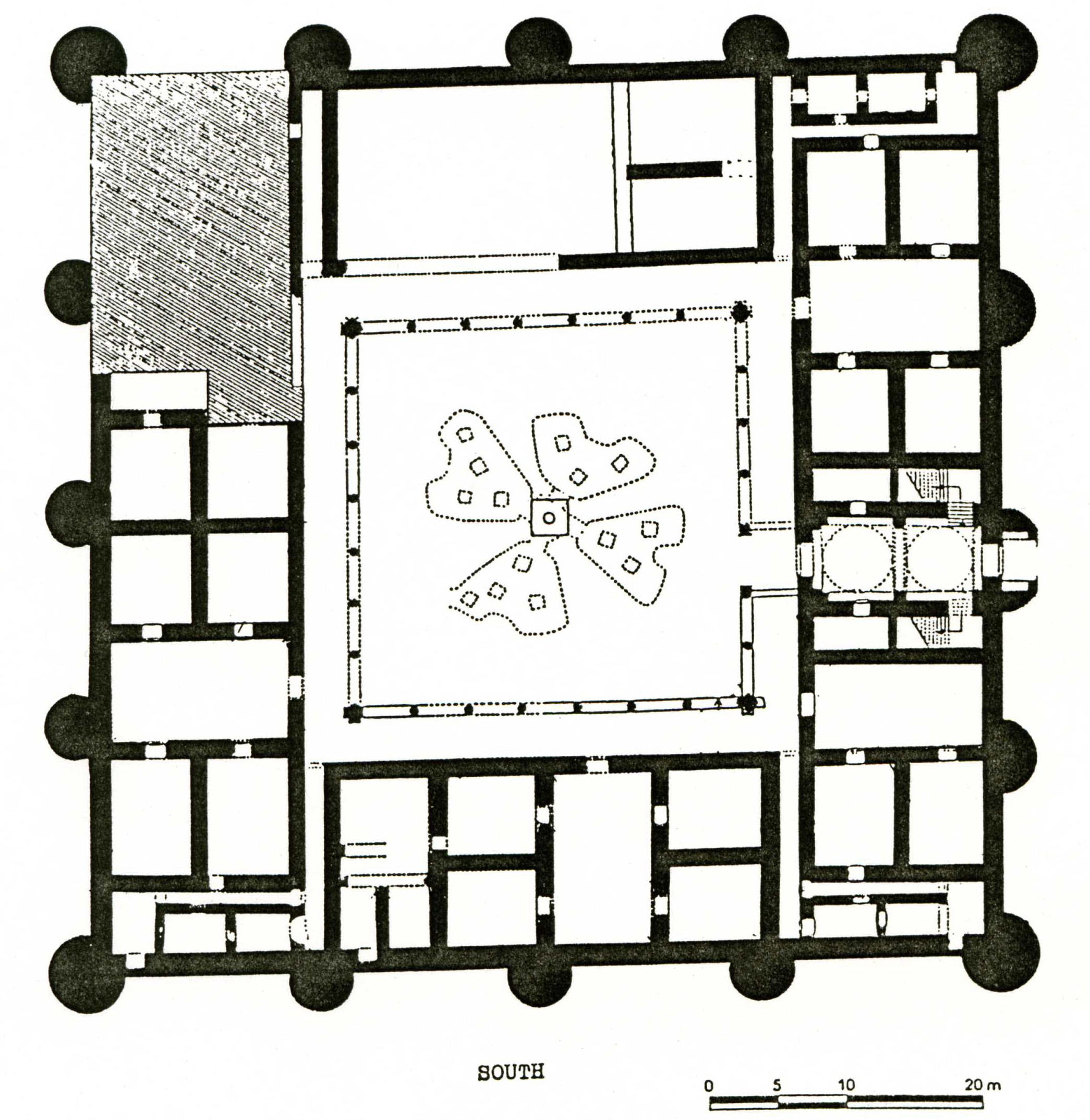
plan général du palais omeyyade, relevé et restitution Frédéric MORIN Architecte

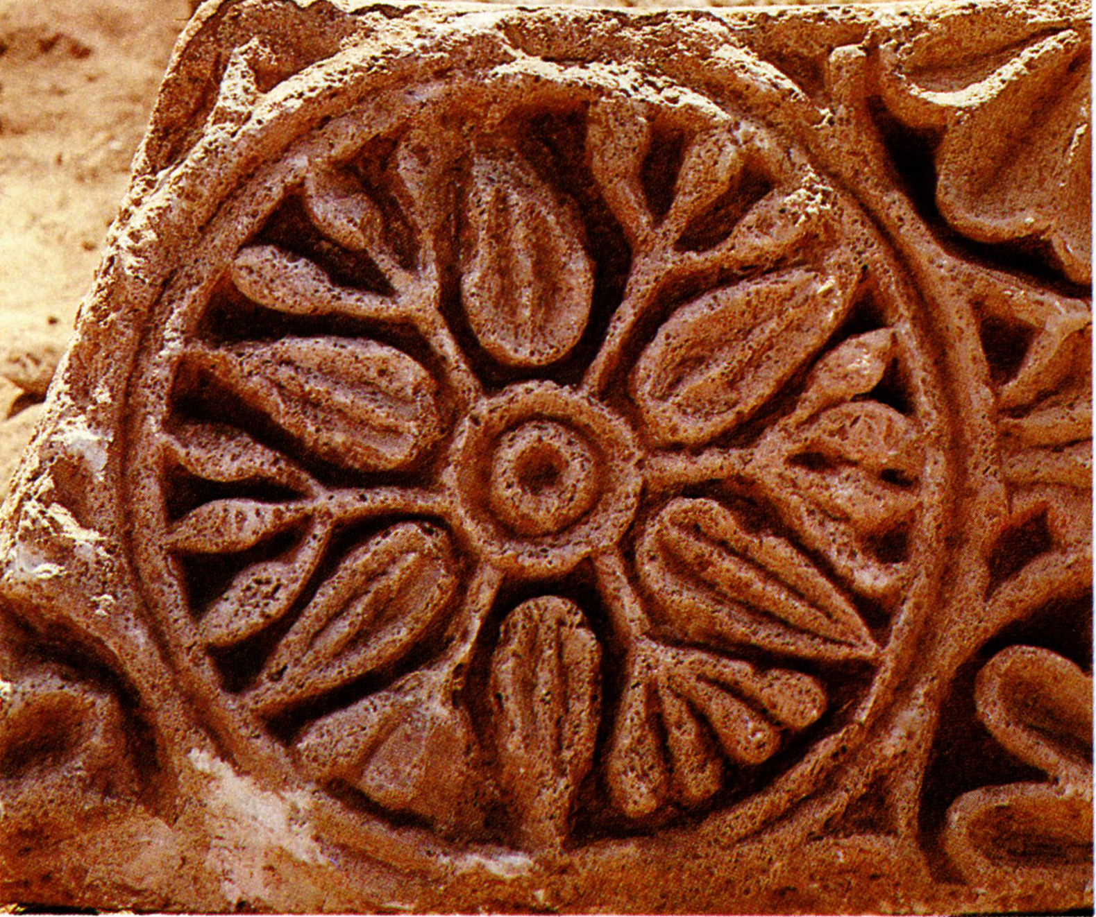
le luxueux décor sculpté en pierre du palais de Qastal

les pavements de mosaïques réalisés par des spécialistes chrétiens de l'Ecole de Madaba - Mont Nébo

ARCHEOLOGIA Oct.1985 : l'Architecture du château de Qastal :

ARCHEOLOGIA Oct.1985 : l'Architecture du château de Qastal :

ARCHEOLOGIA Oct.1985 : l'Architecture du château de Qastal :

ARCHEOLOGIA Oct.1985 : l'Architecture du château de Qastal :

https://whc.unesco.org/en/tentativelists/1550/
Al Qastal (Settlement) -- Jordan
UNESCO HERITAGE
Date of Submission: 18/06/2001
Criteria: (i)(iii)(iv)
Category: Cultural
Submitted by:
Ministry of Tourism and Antiquities. Department of Antiquities.
Coordinates: Utm East:778300 - Utm North:3516200 UTM Zone:36
Ref.: 1550
DESCRIPTION :<
An Umayyad complex (settlement) lies at the modern village of Qastal, 25 kilometres south of the Capital (Amman)
and 100 metres west of the airport Highway. It is one of the oldest and most complete Umayyad provincial communities
in the Near East.
It retains nearly all the structures that comprised a typical Umayyad settlement: a main residential palace, a mosque,
a cemetery, a bathhouse, domestic dwellings, a substantial agricultural dam, a main reservoir and dozens of
smaller cisterns.
Qastal had always been viewed as a small Roman fort, largely because of its fort-like shape and the assumption that
its Arabic name Qastal derived from the Latin word "castellum", or small castle.
Surface examinations by the German scholar Heinz Gaube and excavations by a French team headed by Dr Patricia Carlier
and Frederic Morin have shown Qastal to be a virtually complete Umayyad complex, with the standing remains of what may be
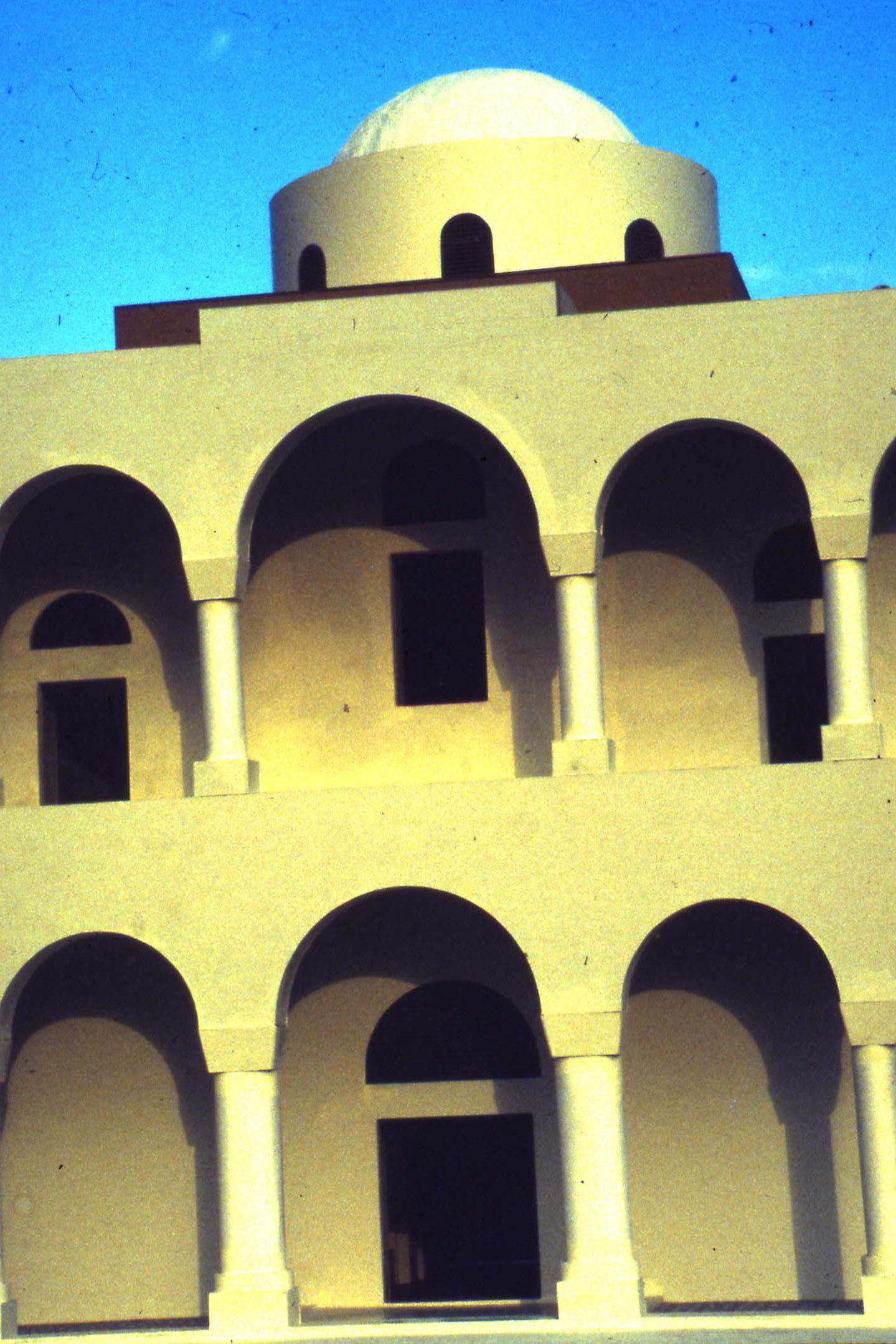
the earliest known Umayyad residential palace and minareted mosque. The palace, nearly 68 metres square, had its
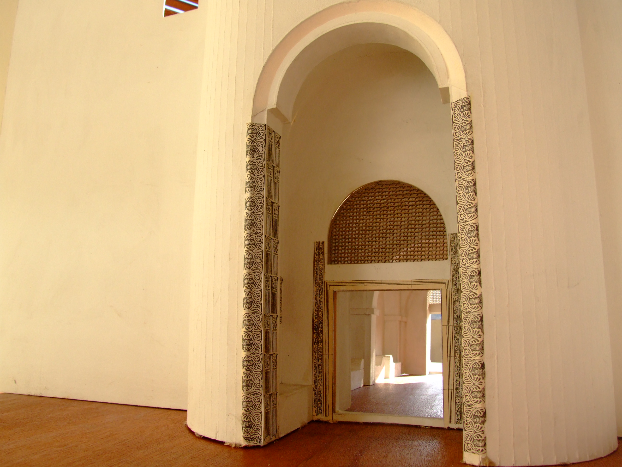
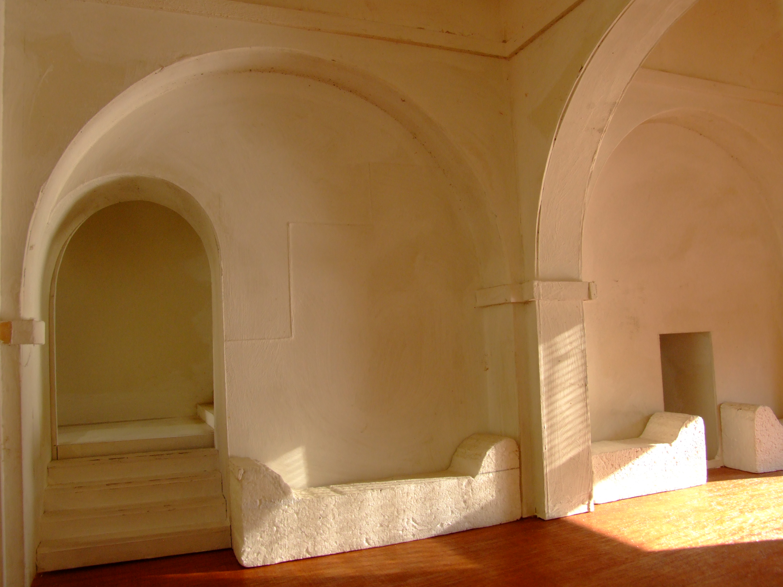
main entrance hall, decorated with fine carved stonework, in a tower in the east wall.
The palace had four circular corner towers and 12 semi-circular interval towers. The excavated south-east corner tower
retains some of the original internal rooms, which were modified when the building was re-used in the Mamluke period
(13th-15th Centuries AD). The entrance hall led into a vestibule which opened on to the central courtyard with a
large underground cistern and surrounded by six "suites"; another six suites comprised the upper storey, reached by
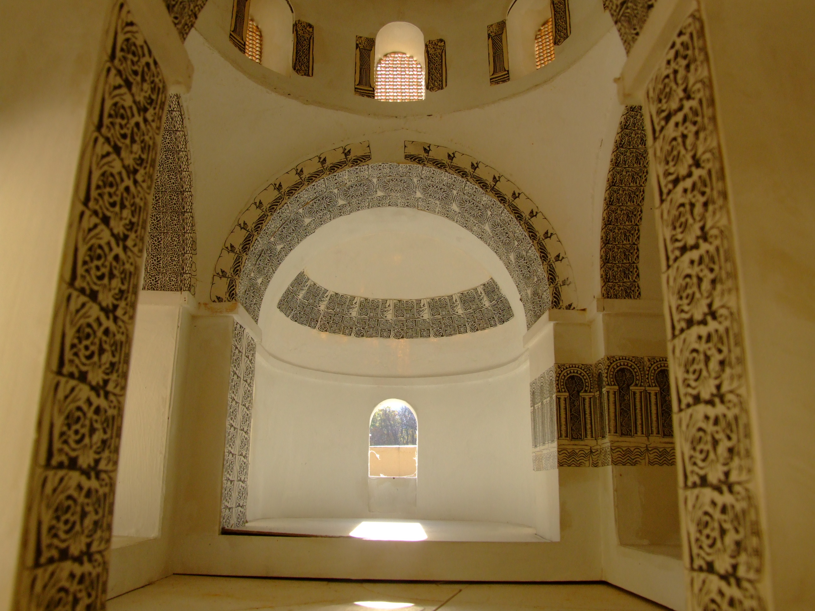
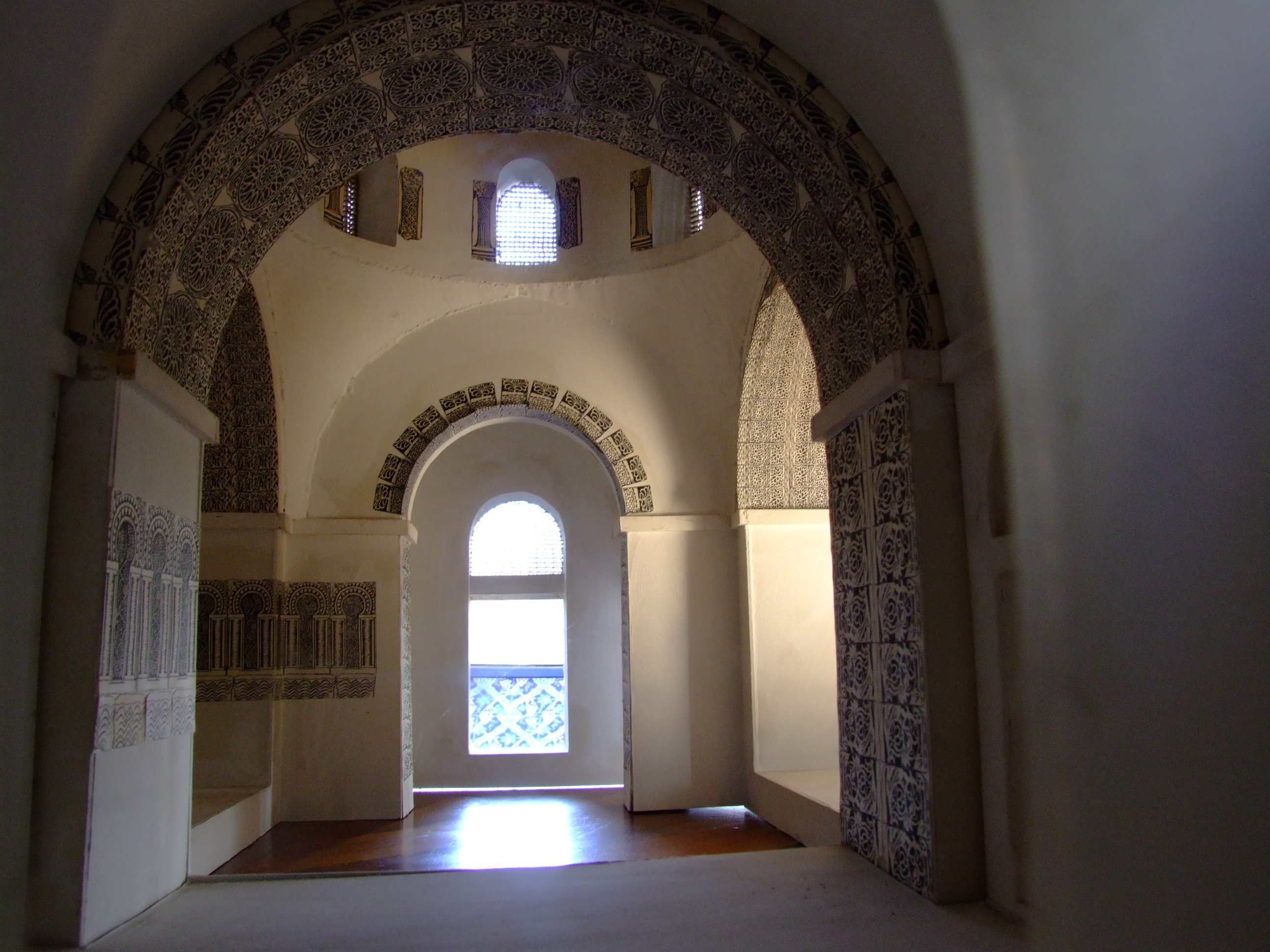
twin staircases within the thick flanking walls of the entrance hall. Above the entrance, on the second floor,
was the lavishly decorated, triple-apsed Audience Hall, similar to the one on the Amman Citadel.
The palace was richly decorated with carved stones, stucco and glass and stone mosaics; its floors, even its latrines,
were virtually all paved with mosaics, whose geometric, floral and animal motifs recall the fine mosaics at
Qasr el-Hallabat.
Immediately north of the palace (across the small paved road) is the rectangular mosque, oriented off-axis from Mecca.
Its original rectangular mihrab (prayer niche) was later replaced by a more typical semi-circular mihrab, and its
circular minaret is one of the earliest surviving minarets from the first days of the realm of Islam.
South-west of the palace is the only known early Islamic cemetery in Jordan with some of its earliest tombs oriented
towards Jerusalem, and with at least 17 inscribed tombstones dated to the Umayyad and the Abbasid periods.
The tombstones are on display at the Madaba archaeological museum, along with fragments of Qastal's mosaics.
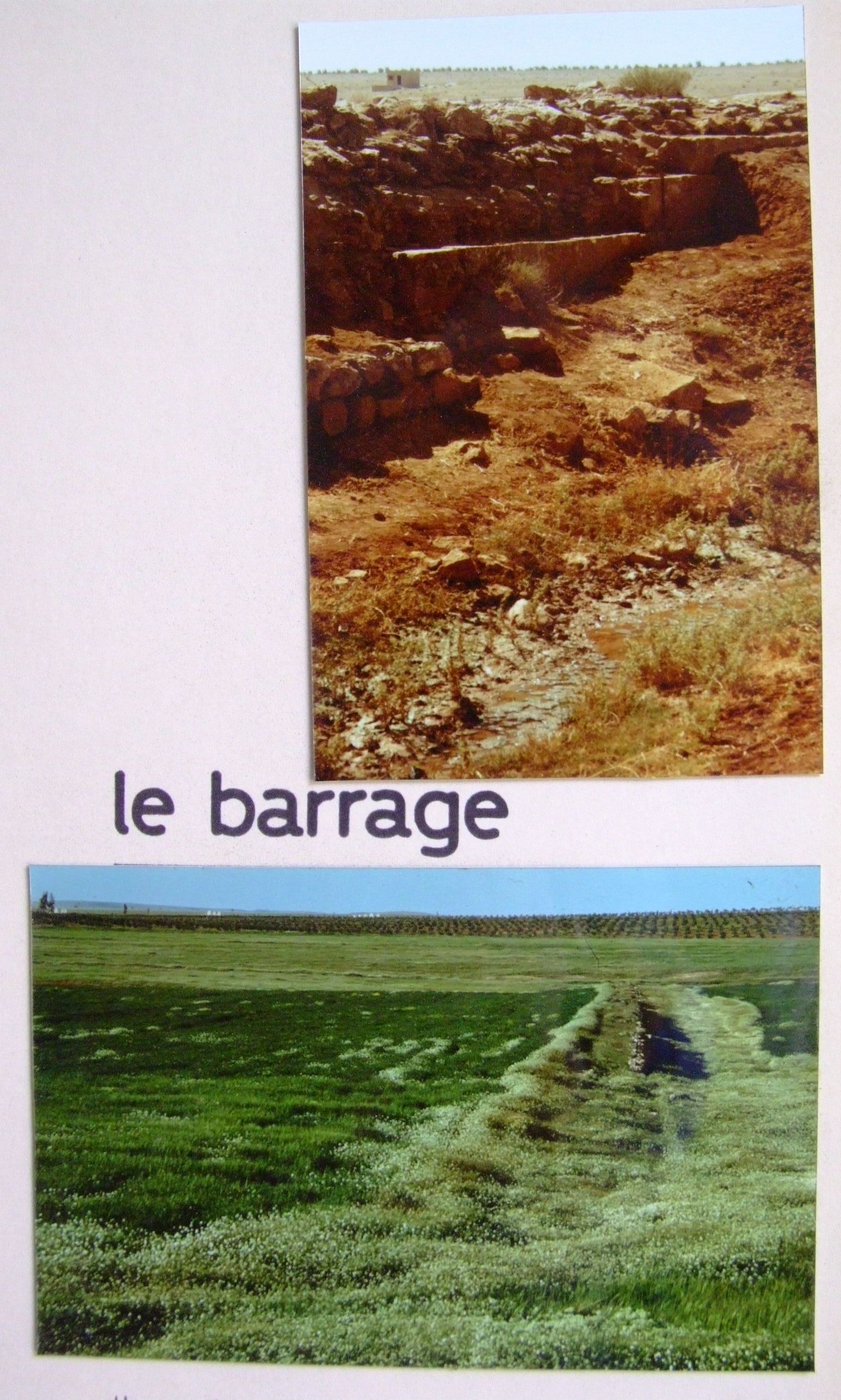
Over a kilometre to the east, across the airport highway, is the 400-metre-long, 4.3-metre-thick stone dam built
by the Umayyad inhabitants of Qastal to store nearly two million cubic metres of rainwater for irrigation.
About a kilometre north-west of the palace, at the edge of the modern village of Qastal, is the large reservoir
measuring 30x22 metres and 6.5 metres deep, with a capacity of 4,000 cubic metres. It was formed from the quarry
which supplied Qastal's building stones for the palace, mosque and dam. In the centre of the reservoir is the
lower section of its original water gauge.
Over 70 smaller cisterns within two square kilometres of the palace provided the settlement's year-round water needs.
West of the palace are some faint remains of Qastal's Umayyad baths. Traces of an ancient road from the Roman/Byzantine
period have also been identified about a kilometre south-west of Qastal, passing adjacent to the archaeological mound
of Zabayir el-Qastal, which seems to have been settled during the Iron Age and the Nabataean, Roman and Byzantine periods.
HISTORY :
The palace is thought to have been built by the Umayyad Caliph Abd el-Malik ibn Marwan (685-705 AD), one of early
Islam's greatest builders, who was also responsible for the construction of the Dome of the Rock in Jerusalem.
Qastal's early date also explains why it was completed and inhabited unlike some other Umayyad desert complexes in Jordan
which were never finished. It is probably the oldest known Umayyad settlement in this area. It seems to have been used
throughout the Umayyad period, and was probably used by the Calip Walid II (743-44 AD) while Mushatta was being built
just five kilometres to the east. The Umayyad poet Kuthayyir 'Azza, who was at the court of Yazid II at Muwaqqar
in 723 AD, mentioned it by the name "Qastal el-Balqa".
The site was used well into the Abbasid period (750-969 AD),
as we know from the tombstone inscriptions. After a brief abandonment, it was re-used as a less grandiose residential area
during the Ayyubid / Mamluke period (1171-1516 AD). Many of the poorly built but still standing walls within the central
courtyard represent Ayyubid/Mamluke domestic structures.
by Ministry of Tourism and Antiquities, Department of Antiquities
complété et mis à jour le 16 juin 2025
mentions-légales
DROIT DES IMAGES :
Lorsqu'il a été enregistré
par son auteur dans
les métadonnées associées
à chaque image numérique,
le nom de chaque auteur ainsi connu
est mentionné dans la légende
qui apparaît lorsqu'on survole la photo
avec le curseur de la souris.
Si vous souhaitez que l'une de vos photos
soit supprimée de ce site pédagogique
promouvant l'intelligence et l'ingéniosité,
les qualités techniques et esthétiques du
patrimoine architectural mondial
dans le cadre du "FAIR USE" et des
conditions de l'exception pédagogique
d'utilisation des photos,
merci de contacter le webmaster :
ici
elle sera supprimée sans délai.


section générale Est-Ouest, relevé et restitution Frédéric MORIN Architecte

section générale Est-Ouest, restitution des dispositions omeyyades par Frédéric MORIN Architecte

plan général du palais omeyyade, relevé et restitution Frédéric MORIN Architecte
le luxueux décor sculpté en pierre du palais de Qastal

les pavements de mosaïques réalisés par des spécialistes chrétiens de l'Ecole de Madaba - Mont Nébo

ARCHEOLOGIA Oct.1985 : l'Architecture du château de Qastal :
ARCHEOLOGIA Oct.1985 : l'Architecture du château de Qastal :
ARCHEOLOGIA Oct.1985 : l'Architecture du château de Qastal :


https://whc.unesco.org/en/tentativelists/1550/
Al Qastal (Settlement) -- Jordan
UNESCO HERITAGE
Date of Submission: 18/06/2001
Criteria: (i)(iii)(iv)
Category: Cultural
Submitted by:
Ministry of Tourism and Antiquities. Department of Antiquities.
Coordinates: Utm East:778300 - Utm North:3516200 UTM Zone:36
Ref.: 1550
DESCRIPTION :<
An Umayyad complex (settlement) lies at the modern village of Qastal, 25 kilometres south of the Capital (Amman) and 100 metres west of the airport Highway. It is one of the oldest and most complete Umayyad provincial communities in the Near East.
It retains nearly all the structures that comprised a typical Umayyad settlement: a main residential palace, a mosque, a cemetery, a bathhouse, domestic dwellings, a substantial agricultural dam, a main reservoir and dozens of smaller cisterns.
Qastal had always been viewed as a small Roman fort, largely because of its fort-like shape and the assumption that its Arabic name Qastal derived from the Latin word "castellum", or small castle.
Surface examinations by the German scholar Heinz Gaube and excavations by a French team headed by Dr Patricia Carlier and Frederic Morin have shown Qastal to be a virtually complete Umayyad complex, with the standing remains of what may be the earliest known Umayyad residential palace and minareted mosque. The palace, nearly 68 metres square, had its main entrance hall, decorated with fine carved stonework, in a tower in the east wall.
The palace had four circular corner towers and 12 semi-circular interval towers. The excavated south-east corner tower retains some of the original internal rooms, which were modified when the building was re-used in the Mamluke period (13th-15th Centuries AD). The entrance hall led into a vestibule which opened on to the central courtyard with a large underground cistern and surrounded by six "suites"; another six suites comprised the upper storey, reached by twin staircases within the thick flanking walls of the entrance hall. Above the entrance, on the second floor, was the lavishly decorated, triple-apsed Audience Hall, similar to the one on the Amman Citadel.
The palace was richly decorated with carved stones, stucco and glass and stone mosaics; its floors, even its latrines, were virtually all paved with mosaics, whose geometric, floral and animal motifs recall the fine mosaics at Qasr el-Hallabat.
Immediately north of the palace (across the small paved road) is the rectangular mosque, oriented off-axis from Mecca. Its original rectangular mihrab (prayer niche) was later replaced by a more typical semi-circular mihrab, and its circular minaret is one of the earliest surviving minarets from the first days of the realm of Islam.
South-west of the palace is the only known early Islamic cemetery in Jordan with some of its earliest tombs oriented towards Jerusalem, and with at least 17 inscribed tombstones dated to the Umayyad and the Abbasid periods. The tombstones are on display at the Madaba archaeological museum, along with fragments of Qastal's mosaics.
Over a kilometre to the east, across the airport highway, is the 400-metre-long, 4.3-metre-thick stone dam built by the Umayyad inhabitants of Qastal to store nearly two million cubic metres of rainwater for irrigation. About a kilometre north-west of the palace, at the edge of the modern village of Qastal, is the large reservoir measuring 30x22 metres and 6.5 metres deep, with a capacity of 4,000 cubic metres. It was formed from the quarry which supplied Qastal's building stones for the palace, mosque and dam. In the centre of the reservoir is the lower section of its original water gauge.
Over 70 smaller cisterns within two square kilometres of the palace provided the settlement's year-round water needs. West of the palace are some faint remains of Qastal's Umayyad baths. Traces of an ancient road from the Roman/Byzantine period have also been identified about a kilometre south-west of Qastal, passing adjacent to the archaeological mound of Zabayir el-Qastal, which seems to have been settled during the Iron Age and the Nabataean, Roman and Byzantine periods.
HISTORY :
The palace is thought to have been built by the Umayyad Caliph Abd el-Malik ibn Marwan (685-705 AD), one of early Islam's greatest builders, who was also responsible for the construction of the Dome of the Rock in Jerusalem. Qastal's early date also explains why it was completed and inhabited unlike some other Umayyad desert complexes in Jordan which were never finished. It is probably the oldest known Umayyad settlement in this area. It seems to have been used throughout the Umayyad period, and was probably used by the Calip Walid II (743-44 AD) while Mushatta was being built just five kilometres to the east. The Umayyad poet Kuthayyir 'Azza, who was at the court of Yazid II at Muwaqqar in 723 AD, mentioned it by the name "Qastal el-Balqa".
The site was used well into the Abbasid period (750-969 AD), as we know from the tombstone inscriptions. After a brief abandonment, it was re-used as a less grandiose residential area during the Ayyubid / Mamluke period (1171-1516 AD). Many of the poorly built but still standing walls within the central courtyard represent Ayyubid/Mamluke domestic structures.
by Ministry of Tourism and Antiquities, Department of Antiquities
 www.frederic-morin-salome.fr
peindre en blanc -2)filtrer le soleil -3)ventiler la nuit -4)évaporer de l'eau -5)stocker l'eau de pluie -6)capter l'eau de pluie -7)installer des capteurs photovoltaïques d'auto-consommation")
 MYTHES ET RÉALITÉS


 exploitations agricoles musulmanes
 fouilles du site jordanien